
"Distances from wonderful places archaeological treasures World Heritage Sites "
|
Paralio Astros 1χλμ Paralio Astros is located in the eastern Peloponnese on the coast of the prefecture of Arcadia and is bathed by the Argolic Gulf.The second national assembly took place here in 1823 during the years of the Greek Revolution |
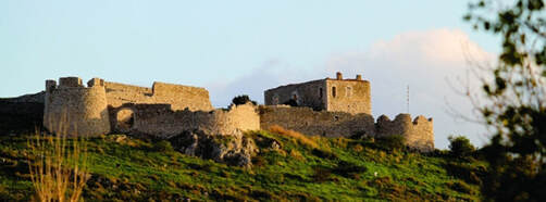
"The castle was called Castello della Estella, meaning Castle of the Star, because of the asteroid shape of the peninsula on which it was built"
|
|
Nauplion 31χλμ Nauplion is a city in the Peloponnese characterized as a traditional settlement and was the first capital of the Greek state in the period 1828-1833. |
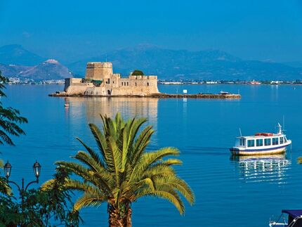
Bourtzi "fortress island" dominates in the middle of the sea. Castello dello Soglio "Throne castle" is the first name of the Venetian castle.
|
|
Ancient Epidurus
67χλμ Epidaurus is the most important ancient place of worship of the medical god Asclepius. It has been part of its world cultural heritage since 1988 of UNESCO. 2 national assemblies were held in Epidaurus during the Greek revolution. The first on 20-12-1821 which declared the independence of the Greek nation and the second in March 1826. |
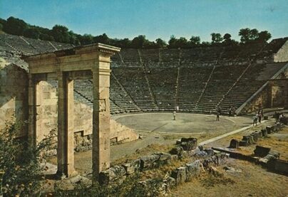
In a ravine, in 340 BC, the ancient architect Polykleitos the Younger built, according to Pausanias, the theater of Epidaurus. Intended for the entertainment of patients has a capacity of 13,000 spectators.
|
|
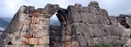
Mycenae 42χλμ During the 2nd millennium BC,Mycenae was one of the largest centers of Greek culture, being a strong military fortress that dominated most of southern Greece. The period of Greek history between 1600 BC. until about 1100 BC. is called "Mycenaean", referring to Mycenae. Recognized as an UNESCO World Heritage. |
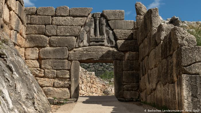
The Mycenaean Civilization was the first Greek civilization of the Late Bronze Age, developed during the period 1600-1100 BC. mainly in central and southern mainland Greece.
|
|
Argos 31km It is considered the oldest city in Mainland Europe due to the existence of many archeological monuments dating from the Late Bronze Age, when it was one of its most important centers of Mycenaean Civilization and one of the oldest in Greece.Foronikon Asty, as Argos was called before it acquired its current name, is considered by many to be the first city in the world. |
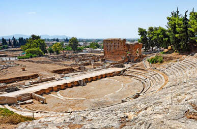
The Theater was founded in the southeastern foothills of the hill of Larissa during the Hellenistic period (300-250 BC). With a capacity of about 20,000 spectators, it is one of the largest ancient theaters in Greece
|
|
Sparta 79km It is also mentioned by Homer in his epics, the Iliadand the Odyssey as one of the most powerful Mycenaean kingdoms and seat of Menelaus, brother of King Agamemnon of Mycenae in the period before the Trojan War. |
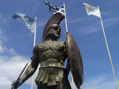
The sacrifice of the 300 of Leonidas and the 700 Thespians in the strait of Thermopylae in 480 BC. would become the most shocking event of this period, as the Spartans fell obeying the unwritten law which stipulated that they should not leave the battlefield.
|
|
Ancient Olympia 213km Olympia, was the most glorious sanctuary of ancient Greece dedicated to Zeus. It was the venue of the Olympic Games which were held in the context of the Olympics, the most important holiday of the Greeks during most of antiquity. Recognized as an UNESCO World Heritage. |
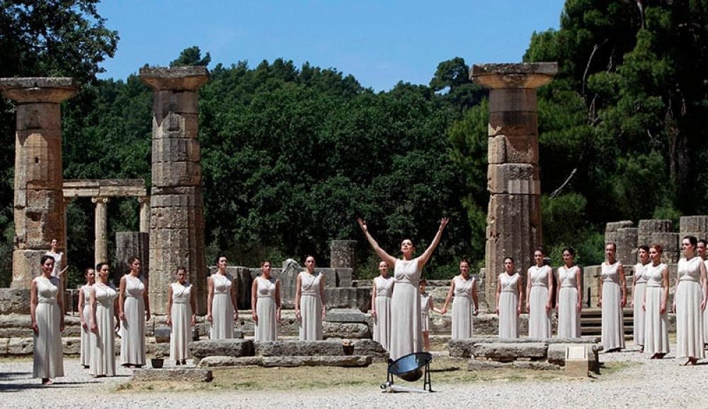
In the 10th century BC. with 9th century BC. the sacred space of Altea is formed with the establishment of the worship of Zeus.
|
|
Athens
157km Athens is the capital of Greece since 1834 and the largest city in the country.It is located in Attica, in the east and is one of the oldest cities in the world, with its recorded history reaching up to 3,200 BC.The name of the city of Athens comes from the patron goddess Athena. The Acropolis of Athens is UNESCO World Heritage monument. |
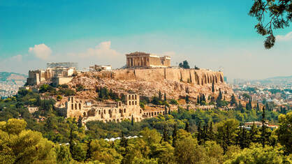
The Parthenon is the largest and most official building of the Acropolis. Work on the construction of this all-marble temple of Athena began in 447 BC. under the direction of the architects Iktinos and Kallikrates.
|
|
Temple of Epicurean Apollo
111km Temple of Epicurean Apollo in Vasse of Figalia is one of the most important and imposing of antiquity. It was dedicated by the Figs to Apollo because it helped them overcome a plague epidemic. This monument, one of the best preserved of classical antiquity was the first in Greece declared a World Heritage Site by UNESCO 1986. |
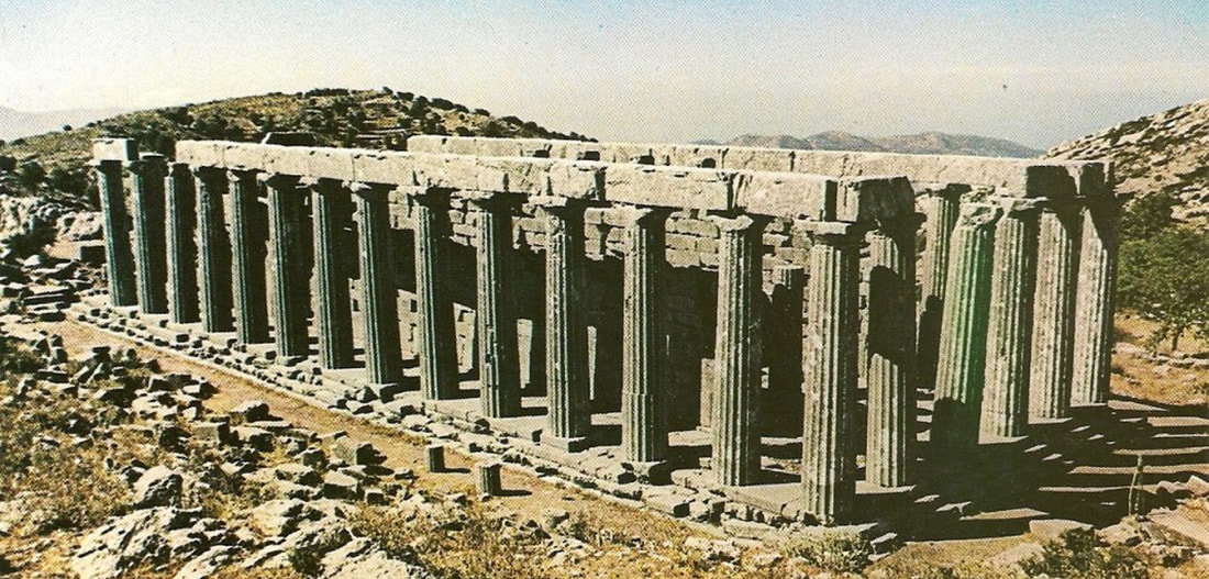
The temple was built in the second half of the 5th century BC. (420-410 BC?) And is attributed to Iktinos, the architect of the Parthenon..
|
|
Diros Caves 160χλμ The cave began to form hundreds of thousands of years ago. The stalactites and stalagmites that are now under water formed when the sea surface was much lower than its current level. |
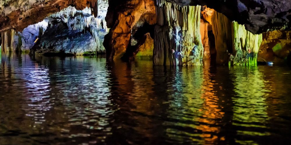
The cave, during the Late Neolithic Period (4000 3000 BC), was used as a shelter, residence, workshop, warehouse, cemetery and place of worship.
|
|
Mystras 84km Located in Taygetos, near to ancient Sparta, Mystras was the capital of the Byzantine Despotate of Mystras in the 14th and 15th centuries. Recognized as a monument its world cultural heritage of UNESCO |
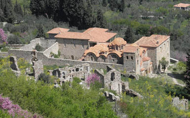
The history of the "dead state" of Mystras today begins in the middle of the 13th century, when the conquest of the Peloponnese by the Franks was completed.
|
|
Tripoli 43km Tripoli is a city in the central Peloponnese,the largest city and capital of the prefecture of Arcadia.The siege of Tripoli began in April 1821 and ended on September 23 of the same year, when the Greeks launched a general attack and liberated the city.The liberation of Tripoli largely determined the success of the Greek Revolution |
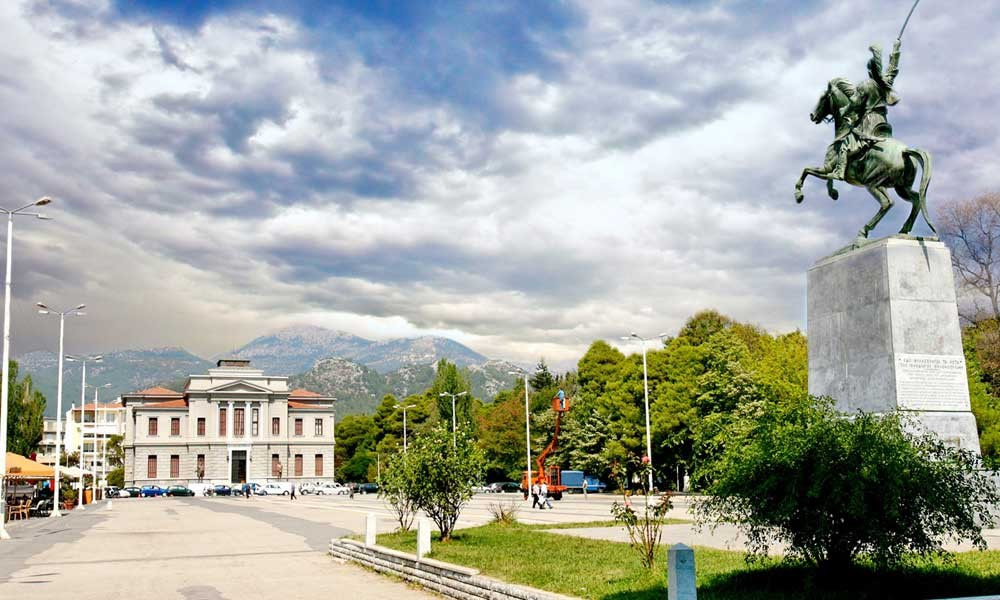
Theodoros Kolokotronis was a Greek general and leading figure of the Revolution of 1821, chief, proxy, Councilor of the State. Acquired the nickname Geros of Moria. After his death he was honored by the Greek state with the rank of Marshal.
|
|
Monemvasia 139km Monemvasia , known to the Franks Malvazia, is a small historic town in the eastern Peloponnese, in the prefecture of Laconia. It is better known than the medieval fortress, on the homonymous "Rock of Monemvasia", which is literally a small island connected by a bridge in a formed neck of a total length of meters with the current coast opposite the city on the Laconian coast. The area of Monemvasia is a protected habitat of the Natura 2000 network |
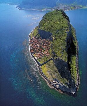
The rescued buildings and structures in the castle include defensive structures of the outer castle and several small Byzantine churches.
|
|
Methoni-Koroni 169km In Homeric times it was called Pidasos.Homer refers as beloessa .It also lists the city as the last of the seven favored lounges (beautifully painted cities), that Agamemnon offered to Achilles to calm his anger.Some argue that Pidasos corresponds to today's Koroni while Methoni corresponds to Homeric Epia. |
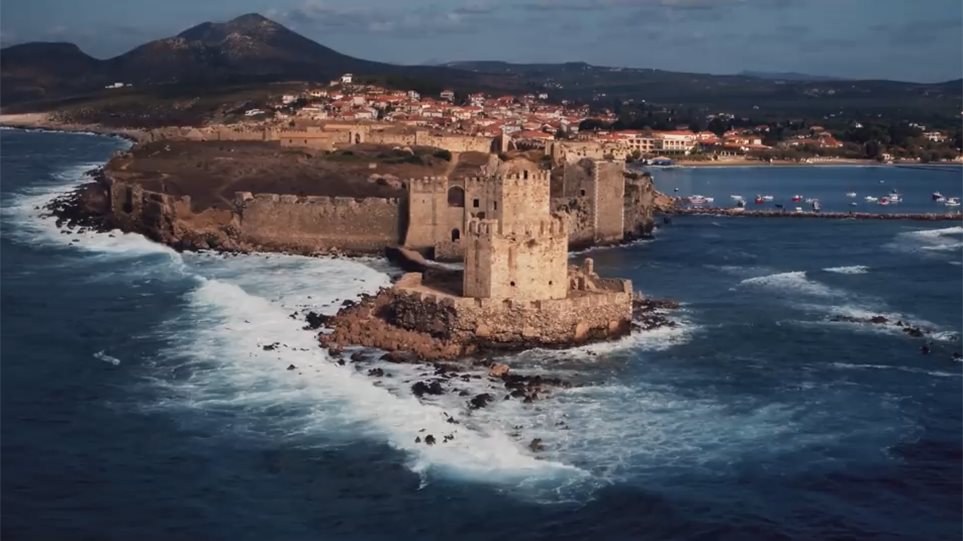
The Venetians fortified Methoni and turned it into an important commercial center. The area experienced significant prosperity and was an important intermediate station between Venice and the Holy Land. The city was then called Modon and kept that name until the 19th century.
|
|
Cape Tainaro 188km Cape Tainaro or Cape Matapas is the southernmost tip of mainland Greece and the Balkan Peninsula.In a small and isolated cave of Tainaros mentions the existence of a necromancer of Poseidon or psychopath both by Pausanias, as well as by Plutarch. |
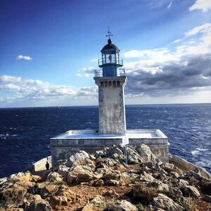
The ancients called it "Metapea Akra" and believed that there was the gate to Hades.
|
|
Corinth Canal
80km The Isthmus of Corinth was known to the ancient world as the landmark that separated the Peloponnese. from the rest of mainland Greece. In the 1st century AD. the geographer Strabo pointed to a column in the isthmus of Corinth, which bore two inscriptions. One to the East,refers that: "τάδ᾽ οὐχὶ Πελοπόννησος, ἀλλ᾽ Ἰωνία" and the other to the West, "τάδ᾽ ἐστὶ Πελοπόννησος, οὐκ Ἰωνία". Plutarch attributed the construction of this column to the hero of Attica Theseus. |
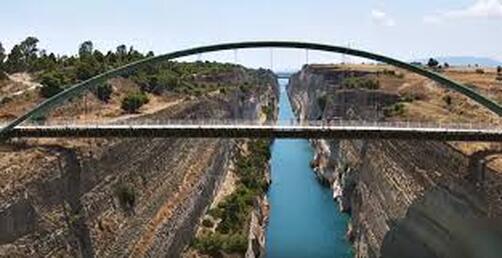
Since 1893, the 6.3 km wide isthmus has opened the Corinth Canal, which in practice makes the Peloponnese an island. Today two road, two railway and two submersible bridges at both ends of the canal connect the mainland side of the isthmus with that of the Peloponnese.
|
|
Pyramid of Elliniko 26χλμ Provided Pyramid of the Elliniko is called a monument in the area of Argos, built on the highway that connected Argos with Tegea. Its name comes from the characteristic pyramid its form. The dating of the building is the subject of controversy, with the initial and most widespread estimate placing it in the 4th BC. century. |
"On the right, as one goes from Argos to Epidaurus, there is a building that looks very much like a pyramid and has relief shields in the shape of Argolic shields. This is what Proetus had fought against Akrisios for the kingdom, and they say that the fight ended in a draw and that is why they later reconciled, since neither of them was able to achieve a decisive victory. They say that then, for the first time, they and their army clashed armed with shields. "For those who fell on both sides, because they were fellow citizens and relatives, a common grave was made in this place". Pausanias (2nd century AD) in the work of Greece tour in the second book, Corinthians.
|